Long Island roads still vulnerable to flooding despite improvements after Sandy
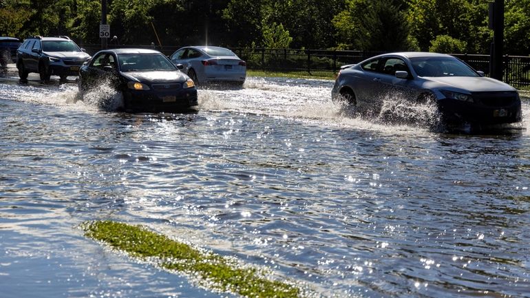
Cars navigate a flooded Searingtown Rd. on Thursday Sept. 2, 2021 in Herricks. Credit: Howard Schnapp
Superstorm Sandy wreaked havoc on the region’s transportation network — turning roads into lagoons, downing trees, knocking out traffic signals, and rendering some roads off-limits for days and even months.
Infrastructure improvements post-Sandy have strengthened Long Island’s roads but climate and construction experts said the work is far from over.
Only 25¢ for 5 months
Superstorm Sandy wreaked havoc on the region’s transportation network — turning roads into lagoons, downing trees, knocking out traffic signals, and rendering some roads off-limits for days and even months.
Infrastructure improvements post-Sandy have strengthened Long Island’s roads but climate and construction experts said the work is far from over.
Since Sandy, the state Department of Transportation has raised roadways, made pavement more permeable, enhanced drainage on various roads and added backup power on some traffic signals.
While the upgrades are important, experts said the entire metro region is not prepared to handle increased precipitation from stronger storms and more severe weather events caused by warming temperatures.
WHAT TO KNOW
- Long Island is vulnerable to climate change and infrastructure needs to be prepared to handle more extreme weather events, including increased precipitation, according to experts.
- The road network has been strengthened since Sandy but experts said there’s room for continued upgrades.
- The drainage system in some areas should be reassessed, experts said.
“All of our infrastructure is typically designed for something like two inches per hour maximum and often the capacity is less, particularly if it was built in an older time,” said Klaus Jacob, special research scientist at Columbia University’s Lamont-Doherty Earth Observatory.
“With rainfalls that approach or exceed two inches per hour, you get all sorts of flooding, including of highways and roads," he said. Culverts designed to divert water away from roads and sewers that drain streets in built-up residential and commercial areas can't keep up, he added.
Hurricane Ida last year brought massive flooding as it dumped as much as 9 inches of rain in some parts of the Island. On the North Shore, there was a record 3 inches of rain in one hour. People were rescued from vehicles on the Northern State Parkway, Northern Boulevard, Lakeville Road, Community Drive and Port Washington.
State transportation officials said they consider the effects of climate change with each project.
“The New York State Department of Transportation takes the issue of climate change and the increasing prevalence of severe weather very seriously and we factor those considerations into every project we undertake,” DOT spokesman Stephen Canzoneri said in a statement.
Several bridges were fortified, including those carrying Robert Moses Causeway over the Fire Island Inlet and the State Boat Channel. In 2019, a section of the Nassau Expressway in the Town of Hempstead was raised 3 to 4 feet above the 100-year flood plain. In 2017, the bases of eight South Shore waterway bridges were reinforced with over 3 million 600-pound rocks to prevent erosion.
The state Department of Transportation repaired two miles of pavement on Ocean Parkway, restored dunes and improved the parkway’s drainage system.
Marc Herbst, executive director of the Long Island Contractors’ Association, said roads still need to be raised in areas of Bayville, Lindenhurst and Freeport.
In 2020, the association commissioned a drainage study that showed many of the systems are in need of upkeep and repair. The report found “significant, recurring, potentially dangerous drainage issues.” Poor drainage can damage roads more quickly.
The DOT has improved the drainage system to help prevent flooding and control stormwater runoff in some areas, including the Northern State Parkway near Carman Road in Dix Hills, State Route 25A at Lawrence Road in Kings Park and the Sagtikos State Parkway at Pine Aire Drive near North Bay Shore.
Long Island is particularly vulnerable to climate change, which is linked to rising levels of carbon dioxide and greenhouse gases and infrastructure needs to be prepared to handle these extremes, experts said.
“As an island of course, Long Island has experienced a lot of these compound effects, maybe more so than other regions of the country, which don’t have to deal with sea level rising on top of extreme changes in extreme rainfall,” said Kevin Reed, a professor and associate dean of research at Stony Brook’s School of Marine and Atmospheric Sciences.
The 2012 superstorm caused storm surge and coastal flooding that devastated communities along the South Shore and low-lying areas across the Island. It was only after the storm dissipated that the fragility of the road network was laid bare.
Over 75% of Nassau County’s roads were blocked by fallen trees and wires and it took about 36 hours to reopen most of them, according to a 2013 a report by the New York Metropolitan Transportation Council. A two mile section of Ocean Parkway was one of the region’s most severely damaged highways and was closed for nearly a month due to flooding damage. In Bayville, West Shore Road didn't reopen until June 2013 and wasn’t fully repaired until 2017.
“If they’ve [roads] been strengthened, I think that they’re less vulnerable than they were 10 years ago today, but our roads degrade over time," Reed said, adding that sections that were not rebuilt after Sandy may not be as resilient.
"You can have a stretch of the highway that is in really good shape, that is strong and well protected, but a storm on the scale of Sandy will find the weakest link.”
Body parts case latest ... Islanders tonight ... Knicks tonight ... Montauk ice problem