Long Island weather: Nicole brings rain, gusty winds
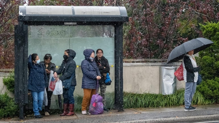
People try to stay dry as they wait for the bus along Northern Boulevard in Great Neck on Friday. Credit: Howard Simmons
Heavy rain and thunderstorms are expected across Long Island early Saturday with a possibility of showers until 1 p.m., as tropical depression Nicole storms across Long Island.
Around midday the skies should clear and western Long Island is expected to become sunny.
The National Weather Service issued a wind advisory for Nassau and Suffolk counties from 10 p.m. Friday until 10 a.m. Saturday. Tree limbs could be blown down and power outages are possible, the advisory stated.
PSEG Long Island reported at 9:30 p.m. Friday that it had 14 outages affecting 404 customers.
A gale warning was in effect until 10 a.m. Saturday for Long Island Sound as well as South Shore waters east to Fire Island Inlet. The warning was extended until noon Saturday for all South Shore waters east to Montauk Point. Mariners were advised to seek shelter or remain in port to avoid what the weather service was advising were likely to be "severe" conditions.
A wind advisory was also in effect from 10 p.m. Friday to 10 a.m. Saturday with gusts up to 50 mph expected, according to the National Weather Service.
High temperatures are expected to be near 70 degrees late Saturday morning but falling into the low 60s for the rest of the day, the weather service said.
That unusual warmth, coupled with the volatile air mass moving through the area from the remnants of Nicole, could lead to as much as 1½ inches of rain, the weather service said.
On Saturday there is a 70% chance of rain, and showers are possible early Sunday, the weather service said.
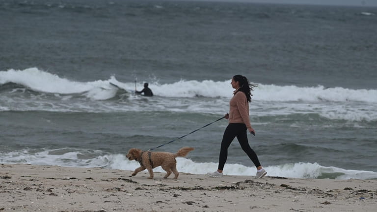
Bonnie Vahlsing and her dog Cody stroll along the shoreline of Shinnecock Inlet in Hamptons Bays on Friday before the worst of the tropical storm's remnants hit. Credit: John Roca
The storm system is “progressive,” meaning it is not expected to linger, and rainfall rates should not top half an inch an hour.
On the ocean, gale conditions are predicted, with seas rising 10 to 15 feet. Beaches may flood and dunes may erode, the weather service said.
Minor flooding could also arise on Nassau’s South Shore.
The storm should last through Saturday morning.
“Showers could be lingering Saturday morning, but dry conditions are expected by the afternoon behind the cold front,” the weather service said.
Storm preparations
On Friday the Metropolitan Transportation Authority, which runs the Long Island Rail Road and Metro-North, was readying crews and equipment — from locomotives to chainsaws and pumps — preparing for winds that could topple trees and bring down power lines.
Aiming “to minimize service disruptions” for railroad passengers, the MTA said it was adding workers, starting Friday afternoon, to quickly fix possible problems with tracks, signals and power caused by "flooding, washouts, downed trees and other potential storm damage.”
For its subways, the MTA’s New York City Transit said it was taking similar measures, including clearing drains and “pre-positioning” track and signal specialists at vulnerable spots.
Previous storms flooded some stations and the agency vowed to swiftly fix any escalators or elevators that are knocked out.
“Even for a system that pumps out millions of gallons of water on a dry day, NYC Transit crews were at subway stations Thursday preparing for the heavy rain," New York City Transit president Richard Davey said.
In a release, the agency said, “Crews are preparing and fueling two trains capable of high-capacity pumping, two trains designed for debris cleanup, and additional emergency trucks and emergency response equipment — including track pumps and chainsaws."
Nassau's bus service, the Nassau Inter-County Express, advised riders in a statement that there might be delays, detours or route cancellations on Saturday caused by downed trees, poor visibility in heavy rain, and possible flash flooding.
On MTA bridges and tunnels, no empty tractor-trailers or tandem trucks will be allowed through 6 p.m. Saturday.
In addition to storm preparations, bridge and tunnel workers "will also monitor wind conditions and implement appropriate traffic or speed restrictions, if necessary, based on conditions," the MTA said.
After warmth, cold and dry
Saturday should be warm, thanks to Nicole.
“Given the warm and moist southerly flow, highs will be about 15 to 20 degrees above normal for mid-November, in the upper 60s to lower 70s,” the weather service said.
The warm weather will cool off Saturday night, sliding to the mid-40s, according to the weather service.
“The coldest and driest air mass of the season begins to build in on Sunday,” the weather service said. “Highs Sunday will be back down in the lower to mid-50s.”
Daytime highs will mainly bounce around the 40s and 50s from then until Thursday, and nighttime temperatures will descend to near freezing
Mostly sunny skies are predicted from Sunday to Tuesday, though rain may arrive Tuesday night. Showers are also possible Wednesday, before the sun returns Thursday.
“The coldest days at this time look to be Monday and Tuesday with highs 5 to 10 degrees below normal, with departures slightly less overnight due to winds staying up to limit radiational cooling," the weather service said.
With John Valenti